The Manual may earn a commission when you buy through links on our site.

West Coast Wild: Three Unique, Remote Hikes in California

remote hikes in california, siskiyou wilderness, kayak camping
Image used with permission by copyright holder
California’s seemingly endless summer makes for awesome year-round hiking, but we’re partial to fall for the slightly cooler weather and thinner crowds which make for great solo hikes. There are plenty of great spots to disappear far off-grid across the Golden State. These are three of the best remote hikes in California.

Find the Bridge to Nowhere

bridge to nowhere san gabriel mountains
Image used with permission by copyright holder

In 1929, construction began near Azusa, California, to connect the town of Wrightwood with the San Gabriel Valley. Among the many bridges required to wind the road through the valley was a unique arch bridge built in 1936. The bridge was among the first to see completion, long before the rest of the route. Unfortunately, a massive rainstorm washed away much of the road before it was finished and the project was subsequently abandoned. Yet, the arched bridge remained — a bridge that connected … nothing. Hence the name: Bridge to Nowhere. It’s one of California’s unique, architectural oddities. Getting to the bridge requires a 10-mile round-trip trek along the San Gabriel River. The hike is moderately challenging, although numerous river crossings mean you’re unlikely to stay dry along the way. The final approach through a high-walled canyon known as the Narrows is the journey’s most dramatic stretch. It is here that hikers will find the Bridge to Nowhere in all its civil engineering glory.

Recommended Videos

Good to know: The Bridge to Nowhere is the base of operations for Bungee America, one of California’s only commercial bungee-jumping outfits.

Explore the Lost Coast

Image used with permission by copyright holder

California’s coastline — particularly the 650-mile stretch that follows State Route 1 — is among the most beautiful, scenic road trips in the U.S. The northern end of the road terminates at its juncture with U.S. Route 101. But, as wise backpackers know, the coast continues for many miles north along what has rightly become known as the “Lost Coast.” The rugged region is the Golden State’s least developed stretch of shoreline. There are no major roads in or out, meaning it’s only accessible on foot. The hike between the Mattole River and Black Sands Beach (near Shelter Cove) requires about three days. Adventurers experience a disparate landscape of untouched forest, beaches, tidal pools, and the peaks of the King Range reaching 4,000 feet high above the Pacific Ocean.

Good to know: This is a one-way hike, so be sure to arrange proper transportation at the opposite end of your trek. The area’s tides are also notoriously extreme, so bring a tidal chart, lest you get stranded in a flooded cove. And never turn your back on the ocean. 

Paddle through Ancient Wetlands

Image used with permission by copyright holder

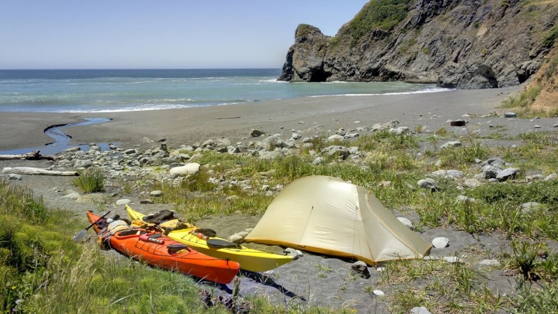
The 6,000-acre Ahjumawi Lava Springs State Park is arguably California’s least-visited state park due to the fact that it’s only accessible by boat. However, the lack of other park-goers and the massive amount of watershed activity make it one of the state’s most worthwhile treks. The name Ahjumawi means “where the waters come together” among the region’s Pit River Native Americans. It’s no surprise when you consider the park is at the confluence of five major watersheds. Outdoor-loving travelers will find no shortage of flora and fauna to seek and photograph here. Whether hiking or kayaking, you’re likely to have the trails and waterways all to yourself. Overnight camping is available with no advanced reservations required.

Good to know: No gear of your own? No problem. Several local outfitters provide rental services for kayaks and racks, as well as half- and full-day tours.

Mike Richard
Mike Richard has traveled the world since 2008. He's kayaked in Antarctica, tracked endangered African wild dogs in South…
How to plan your Glacier National Park visit for 2025: Reservation deadlines and key rules
Here's what Glacier National Park's new reservation system will mean for you in 2025
Hiking Glacier National Park in Montana.

Glacier National Park is one of the most gorgeous ones in the United States, so it's not a surprise that it saw almost three million visitors in 2023. Visitors can't get enough of Going-to-the-Sun Road, Lake McDonald, and the many lakes and glaciers in the area — the best time to visit Glacier National Park is often the busiest time. Because of the congestion in recent years, the National Park Service had previously enacted a reservation system for entry to the park as part of a pilot program. The National Park Service recently revealed this will continue in 2025, including timed entry reservations for the west side of Going-to-the-Sun Road and the North Fork — here's what you need to know.
Here's how it will look like going into 2025
Going-to-the-Sun Road, Glacier National Park Tevin Trinh via Unsplash / Unsplash
West Entrance: Going-to-the-Sun Road

Reservations required: 7 a.m. – 3 p.m., June 13 – September 28.
Applies to travel beyond Apgar Village.
Entry without a reservation: Before 7 a.m. or after 3 p.m.
Exceptions: Visitors with lodging, camping, or certain commercial reservations (originating beyond Apgar checkpoint) will be allowed entry.

Read more
How to plan a day hike: Essential tips for beginners
Day hikes aren't hard to plan; just follow these steps
Man wearing yellow jacket and backpack hiking or rucking in forest or woods with tall trees

Day hikes are one of America's most treasured pastimes, and with some of the most amazing sights for hiking on the globe, it's easy to see why. Nothing beats the fresh air and the invigorating exercise, and the best part is that you can go on these adventures pretty spontaneously. While day hikes require minimal planning, there are still a few things you should bring together before you go.

In this guide on how to plan for a day hike, you'll find essential tips for mapping out your route, packing the right gear, staying nourished, and ensuring your safety on the trail. Follow these steps, and you'll be ready for a successful day hike.
Get the route right

Read more
Insulating your tent for winter camping isn’t as hard as you think
Insulating your tent for winter camping isn't as hard as you think
Woman with a headlamp camping in a winter tent surrounded by snow.

When temperatures drop, and the wind starts howling, heat loss while winter camping can quickly turn a cozy night into a frosty one. The secret to keeping your tent warm isn't about getting the most high-tech gear. Actually, it lies in understanding how heat escapes. From the cold ground beneath you to the sneaky drafts around your tent, each type of heat loss plays a role in how well your tent holds onto warmth. In this article, we'll explore the various ways that heat can sneak away from your tent, as well as how to insulate a tent for winter camping.
Types of heat loss while winter camping and how to avoid them

There are several ways your body and tent lose heat: conduction, convection, radiation, and evaporation. Here's how to avoid all four:
Ways to avoid heat loss due to conduction
Conduction occurs when heat is transferred from your body to colder surfaces, like the ground. To prevent heat loss through conduction, focus on insulating surfaces that come into direct contact with your body.

Read more