
Take in the gorgeous views: The top 5 most scenic hiking locations in America

Cape Royal on the North Rim provides a panorama up, down, and across the Grand Canyon.
Michael Quinn / National Park Service

America has some of the most scenic hiking locations in the whole world. From old favorites to new finds, many of us are constantly getting our hiking boots dusty. If you’re looking for a challenging yet scenic hike to get your loved ones hooked on the great outdoors, it’s your lucky day. KÜHL has just released an eye-opening study about the top 10 most scenic in the USA.

This study looked at 20 different hiking trails from each state and ranked them on a weighted scale based on four parameters:

  • Number of Google Searches
  • Number of Instagram Mentions
  • Number of reviews on AllTrails
  • Number of stars on AllTrails
Recommended Videos

This approach weighs all the different variables in an objective way, so we can really see what’s been popular lately.

Skyline Trail in Beavers Bend State Park

Beaver's Bend State Park
Layne S / Unsplash

Skyline Trail in Beavers Bend State Park, Oklahoma comes in first place with a score of 4.43. This gorgeous trail offers an hiking experience that’s ideal for experienced hikers. This 8.6-mile loop trail is recognized for its difficulty due to the length and steep terrain it covers. Along the hike, adventurers can enjoy diverse features such as lush forests, river views, and even a hidden waterfall with a swimming hole. This trail is especially notable for its beautiful views from higher elevations and is one of the best waterfall hikes in the state.

Be prepared for steep inclines and various water crossings, which can be hazardous, particularly after heavy rainfall. Hikers should also be ready to handle the elevation changes and rugged path conditions​. For those looking for a shorter or less demanding hike, Skyline Trail connects with the Cedar Bluff Trail, a 1-mile loop that offers an easier alternative​.

The Florida Trail in Little Big Econ State Forest

A boardwalk trail through the woods
Tyler Martoia / Unsplash

The second trail on this list is the Florida Trail in Little Big Econ State Forest, which scored a 4.17 in KÜHL’s study. It offers an immersive hiking experience near Oviedo, Florida. This part of the trail, known for its outstanding natural beauty, features a mix of lush forest canopies, river bluffs, and diverse wildlife, making it a popular spot for both local hikers and visitors.

The Little Big Econ section of the Florida Trail includes several loops and segments, with the main loop being 7.2 miles long, offering relatively easy terrain with minimal elevation gain. This makes it accessible for most hikers and ideal for day trips. The trail is multi-use, shared with cyclists and sometimes horses. Dogs are allowed but must be kept on a leash.

Chickadee to Oak Trail Fontenelle Forest Nature Center

Fontenelle National Forest
Tim Umphreys / Unsplash

In third place with a score of 3.51 is the Chickadee to Oak Trail in Fontenelle Forest Nature Center, located in Bellevue, Nebraska, offers a diverse and engaging outdoor experience suitable for all ages. This part of the forest features a network of trails that pass through various ecosystems, including deciduous forests and oak savannas. The trail network at Fontenelle Forest, including the Chickadee to Oak Trail, provides visitors with the opportunity to explore a range of ecosystems. The trails are well-maintained and offer peaceful, natural scenery that is perfect for bird watching and wildlife spotting.

Fontenelle Forest Nature Center is open year-round, with admission fees applicable for adults ($15), seniors($13), and children($9), although members and children under age 2 can enter for free.

Green River to Heritage Trail in Mammoth Cave National Park

Inside the Mammoth Caves at Mammoth National Park in Kentucky.
Sameer D'Costa / Flickr

The Green River to Heritage Trail at Mammoth Cave National Park in Kentucky is a moderately challenging hiking loop. Stretching approximately 2.4 miles with an elevation gain of 374 feet, the trail offers scenic views along the river and through diverse forested areas. It’s popular for hiking and running, and is accessible from March through November.

You don’t need to cough up an entry fee with this one. The first half mile of the trail starts off with a raised wooden walkway that’s accessible by ramps at the start to the trail. After that, the remaining section is a stable cement loop with railings and plenty of benches along the way to sightsee. It’s also pet-friendly!

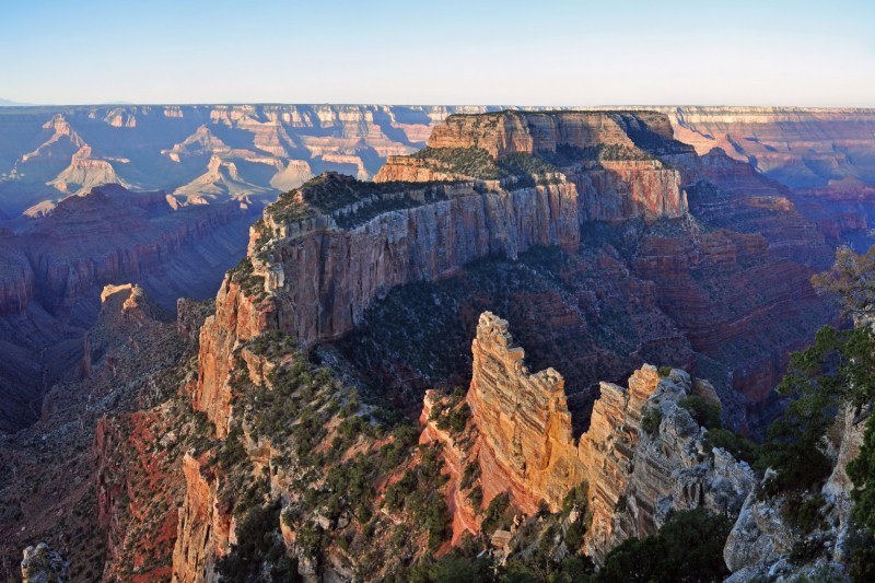
South Kaibab to Cedar Ridge in Grand Canyon National Park

A view of the grand canyon during the day
Quinn Nietfeld / Unsplash

The Grand Canyon has a ton of stellar trails to choose from, but based on KÜHL’s study, the stretch between South Kaibab to Cedar Ridge is the best. This 3-mile round trip hike is often recommended for its dramatic drops. While it’s a relatively manageable distance, it involves a steep descent and ascent, which can be challenging for some people. Some highlights of this stretch includes Ooh-Aah Point, which is offers panoramic views that definitely live up to its name. Then if you continue on, Cedar Ridge offers expansive 360-degree views of the Grand Canyon.

For those planning their next hiking adventure, remember to research your chosen location so you can prepare appropriately for each trail’s specific challenges. Don’t feed any wildlife and always leave no trace to preserve the beauty and integrity of these natural wonders.

Topics
Sarah Joseph
Sarah is a lover of all things outdoors. With a bright sense of adventure and a heart for the mountains, she is always…
3 duct tape camping hacks: Why it should always be in your hiking or camping kit
Stick to duct tape while camping — here's how
Closeup of two friends setting up a tent in the woods.

One of the most useful scenarios for duct tape is out in the wilderness, but it can be tricky to figure out how to store it. One of my go-to ways is to simply wrap several feet of duct tape around an old credit card or a sturdy piece of cardboard. I've also seen people wrap duct tape around their water bottles, but that's never appealed to me since it can be a bit of a mess to clean. Regardless of how you do it, taking some duct tape with you might just make or break your next camping or hiking trip. Here's how.
3 uses for duct tape while out in the wilderness

Patch repairs with duct tape
Sleeping pads pop and nylon tears. We've all been there, and duct tape can save the day! It's great to have duct tape on hand to patch a hole or close a gap in my tent. If you happen to accidentally tear your sleeping bag, a patch of duct tape will get you through it. Reinforce broken straps, seams, zippers, or even sole separation in your shoes and you'll make it home all right.
Duct tape in first aid
When thinking about duct tape, first aid might not always come to mind. However, duct tape is great in a jiffy for splint support if you or someone in your party ends up breaking or spraining something. With a piece of clean cloth or gauze, you can create a makeshift bandage in an emergency. You can also use a small square as blister protection if your shoes start rubbing your feet raw.
Using duct tape as an organization tool
While masking tape might work a bit better in this case, duct tape can still be used to label and tag gear or mark items. That said, nothing is better than duct tape if you want to seal an open liquid container. Duct tape can also be used to keep loose cords, tent poles, or stakes bundled together in a pinch.

Read more
How to calculate hiking time and plan for being away
Calculating your hiking speed isn't as hard as you think
Two people hiking together

To most people, planning a hike can be tedious, but for me, packing my bag gets me even more excited for the adventure ahead. One of the most important aspects of preparing for my hike is determining how long it will take to complete it. This is important for several reasons. First, you'll be able to determine what kind of equipment you'll need during that timeframe, and second, you'll be able to tell someone when to expect you back in case you go missing. About 600,000 hikers get lost every year in the U.S., so if you're one of them, calculating this could mean your survival. Here's how to calculate hiking time.
How to calculate hiking time accurately

If you’re an experienced hiker, you might have noticed that sometimes there is an estimated time listed for a hike in a guidebook or app, which is termed "book time." Almost across the board, these hike time estimations are calculated using Naismith’s (Time Estimation) Rule, which essentially says that it takes about 1 hour to hike 3 miles plus an additional hour for every 2,000 feet of elevation gained.

Read more
5 must-see Canadian national parks that will take your breath away
Top national parks in Canada that you need to visit
Moraine Lake at Banff National Park in Canada

I most often cover national parks in the U.S., but today, I'd like to jump across the northern border and rank a few of my favorite Canada national parks. From turquoise waters to coral beaches and arctic landscapes, Canada has so much to explore. The next time you visit, here are five of my favorite national parks in Canada and what you can do there.
Banff National Park in Alberta

When talking about Canada national parks, I can't not mention Canada's very first national park. Banff was established in 1885 and is now a UNESCO Canadian Rocky Mountain Parks World Heritage Site. This area is well known for Lake Louise and Moraine Lake, which have gorgeous turquoise waters surrounded by huge peaks.
What to do at Banff National Park
Hiking is one of the top activities to do here. While you explore over 1,600 kilometers of trails, keep an eye out for elk, bears, and even mountain goats. Six Glaciers Trail is always a favorite, and you can even visit a backcountry teahouse for some refreshments. Banff National Park is also excellent for its scenic drives. The Icefields Parkway between Banff and Jasper has some stunning views of the glaciers, mountains, and lakes.

Read more