You Can Now Tour Every South African National Park with Google Street View

From cosmopolitan Cape Town to the wilds of Kruger National Park to the dramatic Drakensberg Range to  the world-class vineyards of Franschhoek, South Africa is amazing. However, for most Americans, the cost and logistics of a trip this stunning country aren’t realistic.

Thankfully, Google is doing what Google does best by “solving” that problem with technology. The company has just made every South African National Park — and scores of other points of interest throughout the country — viewable with Google Street View.
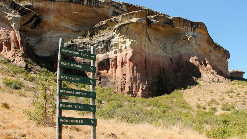
south africa Golden Gate Highlands National Park
South African National Parks/Facebook South African National Parks/Facebook

To pull this off, the tech giant partnered with over 200 volunteers, including some of South Africa’s most expert rangers and preeminent tour guides. Additional contributors included many tech-loving enthusiasts with a passion for the outdoors. (Side note: Google actively encourages anyone who’s interested to borrow their custom backpack and help map the world). Every member of the project was outfitted with a 50-pound backpack rigged with 15 integrated panoramic cameras. Gadgetry inside the high-tech pack used GPS tracking to follow the hiker’s precise location every step of the way. Every two seconds (about once every three feet), a 360-degree photo was snapped. Like Google’s car-driven Street View, the final batch of images was stitched together to create an immersive panoramic tour.

Recommended Videos

Seeds of the initiative date back to March 2016 when Google launched The Mzansi Experience. That project succeeded in mapping South Africa’s most popular tourist attractions, including Table Mountain, Cape Point, and Kruger National Park. This newly completed phase of the project adds all of South Africa’s 19 national parks, plus 17 uncharted nature reserves. In total, 170 new trails were photographed, totaling a walked distance of 560 miles (900 km). More than 230 points of interest were also added, so virtual hikers can now tackle multiple trails to the summit of Table Mountain, track African wildlife on foot, visit the Nelson Mandela Capture Site, and trek the popular Otter Trail.

All but one of South Africa’s UNESCO World Heritage Sites were mapped. The list includes trails on the Drakensberg Mountains, the rugged landscape of the Richtersveld, the civilizations of Mapungubwe Hill, and the country’s oldest UNESCO site at iSimangaliso Wetland Park.

This project joins a long and ever-growing list of already mapped world destinations. Courtesy of Google Street View, armchair travelers can already visit the U.S. National Parks, Australia’s Great Barrier Reef, even the International Space Station.

Feature image courtesy of South African National Parks/Facebook.

Mike Richard
Mike Richard has traveled the world since 2008. He's kayaked in Antarctica, tracked endangered African wild dogs in South…
What you need to know about Big Bend National Park’s temporary closure
NPS to reduce aoudad population at Big Bend to protect native bighorn sheep.
Bighorn sheep

With its rocky mountain landscapes and diverse desert ecosystems, Big Bend National Park in Texas has become a beloved destination for all kinds of adventure seekers since its creation in 1933. One of the greatest sights in the park is the desert bighorn sheep, but the park's herd of bighorn sheep might be in trouble thanks to a non-native species of sheep. As the bighorn population dwindles, the National Park Service and Texas Parks and Wildlife have banded together to conduct a special project before they go extinct in the park. Here's everything you need to know about the efforts and when parts of Big Bend will be closed.
Big Bend National Park's fight to save the bighorn sheep

For many years, the native bighorn sheep in Big Bend have had to compete for limited resources with a large population of non-native aoudad sheep, also known as Barbary sheep, native to North Africa. The aoudads have blocked bighorns from accessing water and threatened the park's biodiversity. They have also become a danger to park visitors just trying to experience the beauty of Big Bend.

Read more
Everything you need to know about viewing fall foliage at Acadia National Park
Leaf-peeping opportunities at this national park destination
A spectacular view of Cadillac Mountain in Acadia National Park in fall

Acadia National Park  in Maine is one of the country's most well-loved destinations for seeing fall foliage. The unique mix of coastal cliffs, forests, and mountains has much to offer leaf-peepers, and a lot of that is due to the diverse variety of tree species found in the area. Multiple kinds of maples, birches, and oaks create a vibrant mix of reds, oranges, and yellows that you won't want to miss.

So, how do you make sure you catch it all this year? Here is everything you need to know about viewing Acadia National Park fall foliage.
How to time your trip to see peak foliage at Acadia National Park

Read more
Science reveals which National Park you should visit for the best fall foliage
Go leaf peeping in these national parks
A spectacular view of Cadillac Mountain in Acadia National Park in fall

The change of seasons is upon us, which means it's time to start thinking about when and where to go to see the stunning colors this year! OnX, an outdoors tech company, is here to help. This brand is well known for off-roading, back country, and hunting map apps, which are trusted by millions nationwide. Now, they have made it easier to gauge leaf peeping prospects by utilizing their state-of-the-art satellites to measure the deciduous tree density in our favorite National Parks. Pack your gear and get ready to explore — here are the National Parks you shouldn’t miss this season.
OnX's top 9 National Parks for seeing fall colors this year

Great Smoky Mountains National Park, North Carolina & Tennessee

Read more